
My tour on Monday, May 21, 2012 continues. I headed east back out of Pembroke turning onto Hwy 148 east of the town by the Esso gas station.
There are three bridges that take you to Allumette Island and cross over Cotnam and Morrison Islands. The first is under going repair so there is a stop light that monitors the traffic. The second comes quickly and you are then greeted by a big blue sign welcoming you to Quebec. If you decide to take photos of the bridge, be careful for the auto’s speed along and don’t wait for anyone and there is not much space along the highway to walk safely. Each bridge gives you different views of the Ottawa River.

Welcome to Quebec

The Ottawa off the 2nd bridge to Allumette Island
The next bridge is the one that finally places you on Allumette Island but the sign reads instead: L’Isle-aux-Allumettes (below on the map it reads lle des Allumettes – there is a ˆ over the l.)

The Big Sign

The small sign for Allumette Island
Just beyond the sign is a grocery store and other businesses including a gas station and restaurant. It was very busy at this store and it was open even on the holiday. I found a map titled Outaouais/Gatineau which gives more detail. They feature cities on the Quebec side but not the towns I am interested in. The Renfrew County Ontario side is on the map but some it blotted out. It goes all the way to Hawkesbury, Ontario but emphasizes the Quebec side. It is very interesting to me that they only feature certain communities. Apparently when you are too small you don’t get mentioned?

Get your supplies here!
Hwy 148 travels up the eastern side of the island to Waltham and another bridge. I turned at Ch. de Pembroke and headed for Chapeau 12 kilometres on the north side of the island. It curves around and you are pretty much in the center of the island. Farms and fields stretch out on both sides of the highway and it is flat. First is the Dejardinsville sign which you can turn left and go exploring but I continued on to Demers Centre which is four corners filled with mostly lovely homes and at least one business. I guess they call them hamlets?
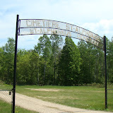
The next stop for me was the what is called the new St. Alphonse Cemetery on the right side of the road. easily to spot but you do have to turn quickly or you can miss the entrance. You can pull in through the gate/sign and drive through part of the cemetery. It was well-kept.

St. Alphonsus Cemetery

New St. Alphonse Cemetery overview
UPDATE 7/09/2012: Here are additional overview photographs of this cemetery. April 28, 2015 Please be advised that there are two cemeteries with almost the same name. This cemetery is south of the village of Chapeau and is the newer cemetery.
UPDATE: August 9, 2023 – Picasa and Album Archive are no longer showing my photos. I will come back at some point and fix this problem.
 |
| St. Alphonsus Cemetery (new) |
During my trip I will stop at various cemeteries and take overview pictures of them. There are websites that you can go to and get photos and listings of the tombstones and those buried there, as well as publications. When I return from this trip I will post more photos and information about each cemetery that I did visit.
The journey continued to Chapeau which was very exciting for me. As you enter Chapeau you will see their fairgrounds to the right.

Chapeau Fair
Chapeau is actually two levels, so when you come from the south you come to the upper level where the municipal building is located on Notre-Dame street and the catholic church, St. Alphonse is situated on Ch. St. Jacques with the library behind the church. If you continue on Ch. Pembroke you drop down to the lower area next to the river and can cross the bridge to Chichester Township.
My first stop was the St. Alphonse Catholic Church where I dallied a while taking pictures of the church and the cemetery which is behind the church and over a block. The church is very difficult to photograph because there is limited room to back up (cliff) and the spire is so tall so that is why this photo looks slightly distorted.
UPDATE: 4/28/2015 the St. Alphonse Church below is in the village of Chapeau and behind it is the older cemetery. The newer cemetery is south of the village of Chapeau about 1 mile. They have almost the same name but they are separate cemeteries. See my post dated 5/28/2012 for more details on this older cemetery.

St. Alphonse Catholic Church
There is a green park area next to the church and it has their war memorial.

Chapeau’s War Memorial
Crossing the bridge to Chichester is a little less scary than the crossing from Pembroke to the island. I was able to stop and take pictures and not fear for my life. The Chenal de la Culbute is part of the Ottawa River which splits and circles the island with the major portion of the river flowing along the west and southern part of the island, while the northern part is the Chenal de la Culbute.

The Chenal de la Culbute to the east

Chenal de la Culbute – looking west
This was very exciting for me because my great-grandfather Archibald McDonell was the locks master. The locks were operated from about 1870 to 1891. The history books and articles keep changing the date when it was abandoned. Archibald is listed as the lockmaster in the Canadian census for 1891 so I tend to think he was still involved at that date. It was made of wood so a lot has rottened away. I tried to figure out its location but failed. I was told by a volunteer at the Pontiac Archives in Shawville that you would have to go to the remains by boat.
So I put out a challenge to someone who knows where the remains of the locks are in the Chenal de la Culbute and would be willing to take pictures for me. Just leave a comment if you wish to contact me to help? I am wondering if they widened the Canal and was told that there were a lot of dams. When I first started research back in 1999 the Culbute lock was not mentioned nor did anyone know about it but I am seeing more on-line. I will revisit later with additional information.
When I was preparing for this trip, I tried to find auto tours. I stumbled onto this website for the Outaouais Heritage WebMagazine that has some very interesting articles and auto tours click on the Outaouais Pontiac Heritage tour and then go to the page 3 for more choices for tours. http://outaouais.quebecheritageweb.com/attractions-and-tours
On the Chichester side you can look back toward Chapeau and you will see the beautiful St. Alphonse Church rising above the trees. Driving along the Ch. St. Jacques going west and then returning you can see the spire in the distance.

Looking back to Chapeau


Put the coordinates in google maps and zoom out a bit. The two small Islands to the left is supposed to be where they were. I have been up there. Not much left since the locks were made of wood. Locals say someone blew them up because of competing logging companies or something like that.way back in the day.
LikeLike
John: Thanks, I did a update just recently on the Culbute Locks on January 26, 2015. just go to the blog and click on the picture at the top and scroll down a couple of posts or use the archive box to the right with the date I gave you. A nice man shared his photos with me. It must have been pretty impressive when it was in full operation per the photos that I link too. The history books don’t mention that there might have been sabotage. HA!
LikeLike
Roughly
LikeLike
Again thanks for stopping by.
LikeLike
From what I have heard this is where the locks were. 45°55’53.7″N 77°10’22.7″W
LikeLike
John: Thanks, I will check it out.
LikeLike